Since the KBC MTB club changed the date for their annual Ardennes ride from October 3rd to September 19th - meaning NEXT weekend - without first asking my opinion I was forced to take a day off from work to do a recon of the route. Why ? Because I am the guide and as such I need to know if there are any track changes and also because it was a while ago since I last did this route completely. Now, obviously, I am not sad to have a reason to go to Theux and muck about a bit on the trails, but the last time I did this ride - last year in September - I made a bad move on my bike causing my back to get hurt. Of course this was playing in my head and I didn't want the same to happen again. The track then sets into the fagnes with a long ascend on bad tarmac turning eventually into a gravel road. The sun peeps through the clouds and Roger is thinking about removing a layer of clothing. I am glad he didn't because there are colder climes awaitign us higher up. At one point I got confused when the GPS reacted too slow to a number of direction changes and we took a wrong turn for about 100 metres. Then I came to my senses and turned around, and so did the GPS. A bit of uphill tarmac, a right turn and we were enjoying the Ardennes again. Track after track, at one point riding into a little river for a short uphill stretch. We came to some kind of chicken garden and again I hesitated and the GPS was too slow deciding where to go. We did a long extra loop. The good thing about navigating with the Edge 705 is that it always gets you back on the track you should be following. But the simple lack of trails made us do an extra 4 or 5K before we were back on the right trail. We were nearing Neufmarteau now and the last stretch of trail along the river Hoegne. In Polleur we had to climb again , and most decidedly so, since we were following a trail that brought us nearly 100 metres higher up the slope. Downhill again - we were on the Red Theux route but riding it in the opposite direction. Arriving in Sassor I take us into a right turn leading towards a steep uphill. Its the last one because after shedding many a droplet of sweat we can see Theux lying below us. Zooming down the downhill we arrive at the road to Verviers again and turn towards the Theux train station and our car.
I contacted my friend Roger to ask him if he would like to come along and I was glad he said yes. It's always safer to not ride alone on these kind of trips. I had manually prepared the GPS track on Mapsource and was set to follow it on the Edge 705. We arrived at the Theux train station at about 10am and quickly after that we were on the move. The weather was grim but dry and with a forecast of clearing skies later in the day.
The KBC MTB club insisted on leaving at the Theux station - me I much more prefer leaving at the Chateau de Franchimont. The extra couple of K's joining the Theux station to the start of the uphill were a bit of a maze into the Theux city back streets. Especially at the local school we were forced to find another track around the school. So I started off on the climb towards the Franchimont Castle. Halfway up there is a track leading down again, dropping us onto a meadow with a 'Private' sign. We could see the track we needed to get to, less than a 100 metres further , so we skipped underneath the barriers and quickly made our way towards the trail. No harm done.
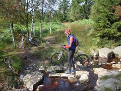
Leaving Theux on the 'Devant Staneu' tarmac street, the climbing begins. Quickly the trail drops back down and re-ascends very steeply to run parallel to the railroad and next to the majestic "Bois de Staneu" for a while. Then I am skipping trails and we were climbing steadily along the Clementine ruisseau towards the Golf de Spa. A bit of tarmac and a nice twisting singletrack leads us towards another trail that Roger enjoyed very much. Me I had been here before but I also love this little singletrack, which goes up and down like a big tobogan with on the right a big dropoff and on the left the forest and the hill going upwards . In Sart another bit of tarmac but quickly we are on a singletrack again. This leads us upwards towards a big road. Crossing this we descend on a forest track towards the real start of the uphill, the "Passerelle Michel Thorez" . This was the exact spot where I hurt my back last year so I was a bit awkward riding here. We stopped to have a little snack and take some pictures.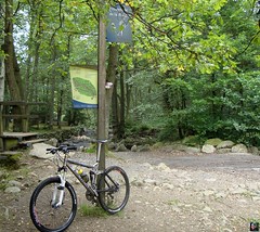
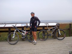
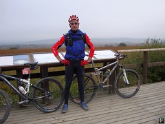
A little descent and then the trail meanders upwards towards the Signal de Botrange. At 692 metres this is officially the highest point in Belgium. It took us 2h30 to reach it and we were about 33K into the ride. Taking Roger towards the viewpoint looking out towards Germany, we noticed it was cold - 14 degrees and a cold northerly wind and still a bit misty. Although the sun was making an effort to pierce through the low cloud cover. We had a snack, took some pictures and got underway for the downhill part of the ride.
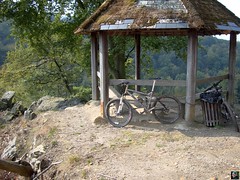
The downhill is a lot more technical that the uphill. At first it is easy with the big gravel roads, but then I take a little track through the Fagnes towards the Vecquee. Having to cross a little river and riding on some wooden elevated paths we reach the larger Vecquee trail. At some points on the Vecquee there was some water - not mud, but plain water - that forced us into the pine tree forest next to it. Here there were roots making life difficult for our full suspension bikes. But things got even more difficult when we reached the end of the Vecquee and came on a rocky and stony doubletrack leading us towards the Hoegne. Having a full suspension bike turns out to be a blessing here. And things got even more technical when I set onto the downhill towards the little pavillion looking out over the deep Hoegne valley. Rocks, ruts, little rivulets crossing the trail and the plain steepness of the descents made us enjoy these trails to the fullest. This is the real Ardennes stuff. Tough and rough. Quickly we were ejected onto the tarmac track we had followed less than an hour ago upwards. But this time we were speeding down towards the Passerelle Michel Thorez again. Here I turned to the right and we encountered the river Hoegne again, having to cross it several times using small wooden bridges. And between the bridges we followed a foothpath strewn with roots, rocks and small puddles. Again our bikes brought us joy.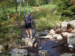
We were very lucky with the weather. It was around 15 degrees when we started and it remained like that until we were descending again. Temperatures then went up towards 18 degrees and the sun was shining more, bringing us light and warmth. Furthermore the tracks were almost dry with only some water high up in the Fagnes. I really enjoyed the ride and from the grin on Rogers' face I'm pretty sure he enjoyed it too. Afterwards I edited my GPS track so that the KBC MTB club could use it next saturday. I uploaded the un-edited version to my Garmin account. Click on the link below to download it and ride this beautiful trail yourself. Be warned though, it takes a fair bit of fitness , some Ardennes experience and a good bike to enjoy it to the fullest.
Ride Stats : 66k and 1140/1215 heightmeters (Polar/Garmin) in 4h29mins
GPS Track on Garmin Connect : CLICK
7135/71635
Thursday, September 17, 2009
Theux Signal de Botrange Theux recon
Subscribe to:
Post Comments (Atom)

No comments:
Post a Comment