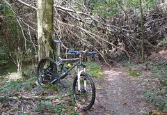
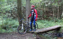
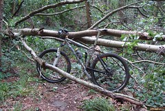
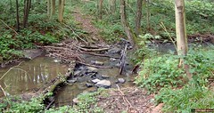
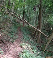
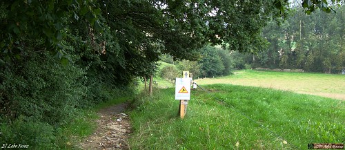
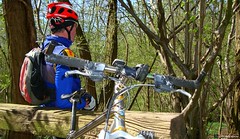
Time to get Mr.Merlin out and do some serious biking in the Ardennes. Or, in this case, the gates to the Ardennes, Ben-Ahin which is a suburb of Huy, near the river Meuse. The O2 Bikers roadbook of Ben-Ahin is already an old one, dating from their number 70 issue from June 2001. It is however, a roadbook that received a lot of credit as being tough, both uphill and especially downhill, with the drop from the Tour Joseph back to the town of Huy as being the epitome of downhill tracks in the region. So today, at last, I rode my MPS towards Huy and parked at the parking lot opposite the Hotel du Fort. This loop starts with a very beautiful but very steep and dangerous downhill. Think in the region of 25% grade, even more. Near the end I am literally sitting on my rear tyre to keep the weight back while I control the speed of the bike. Luckily there are some ground patches between the rocks where I can apply the brakes without risking a washout. I arrive on a tarmac road I follow briefly before entering the forest again. Another climb takes me to a next patch of tarmac and another trails brings me ultimately into Boussale. From there I move towards Andenne, where - at the Col de la Flismes - the track at last veers to the right and brings me back to the river Meuse. Some very nice trails here in the forests. There is a sign with 'Pietons Seulement' - pedestrians only - and I'm betting that most will be indeed going on foor here. The climb is steep, and the trails is riddled with rocks making it very difficult to find traction and keeping the wheels spinning. At the top I follow a narrow track taking me through a field with two basculating gates. The trail then turns back into the forest for another drop down the slope. At the end I nearly have to make a 180 turn that brings me on a small singletrail following a river. The trail ascents and after a while it again becomes too steep to ride. So I walk another 100 meters before the slope lessens. The peak grade on this slope shows 38%. No mere mortal can ride that I'm sure. I arrive in Saint Leonard and have to climb some more on tarmac roads before reaching the Tour Joseph. Crossing the tunnel and I arrive at a bridge from where I see my car down below on the parking lot. Some steps take me down to the road and I am very happy to have survived this difficult ascent at the end of a very physical ride. When I look at the numbers on my Polar and Garmin screen I realize that the 900 heightmeters announced were a bit optimistic. certainly so if you take into account I did one 4K loop 2 times,adding perhaps 70 heightmeters to the normal number. Afterwards on the PC the Garmin software gives me 870 heightmeters. And I can live with that. Especially since most of them were very hard-fought, steep height differences. I realized today that I need some more Ardennes rides to get into better form. I have the endurance but it has been a while since I had to tackle long steeps climbs and descents. 
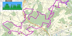
The mist that hung over the country was slowly getting dissipated by the sun so things looked good weather-wise. The roadbook promised nearly 900 heightmeters over close to 34K. More was not needed to draw me out and give it a try.
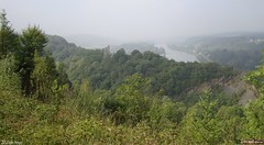
From the start a section of tarmac brings me along the borders of the river Meuse towards the roundabout where a tarmac climb starts. I pass the Chateau of Ben-Ahin - I think thats what the sign said - and then I am riding offroad and getting used to my first couple of kilometers on the Merlin again. The route climbs gently out of the valley and on top of a long climb I am presented with a magnificent view of the river deep below, with some shrouds of mist still hanging over the faraway hills. The trail drops down again and some sharp rocks remind me that I am in the Ardennes and care has to be taken. Below I follow a river upstream until where a multitude of tracks come together on my Garmin screen. I know this is the spot where the trail comes 2 times but I am not sure which direction I should take first. I fumble with the screen and see there is a loop lying ahead of me. I decide to go for that and it takes me onto small singletracks vlimbing more or less all the time. Sometimes a fallen tree blocks the track and getting over it isn't always easy. At one point I make a wrong turn but I can see on my GPS that I will connect to the track again a little bit further. I arrive at Solieres and after some tarmac I drop down on a rooty singletrack into the forest again. Getting my feet wet riding through a little river and then a long steep climb though a hollow road. Steep but just manageable. After a while a tricky downhill brings me into Ben-Ahin where I am taken on a second loop.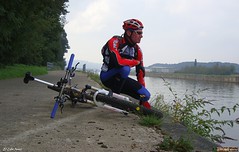
I follow the river Meuse for a while and if I might give a tip to anyone wanting to ride this track, take advantage of this flat section to recuperate because the climb that will follow is a very nasty one. You follow the Meuse valley until you reach Ben, and there starts a climb that will have you dig deep into your strenght and technical prowess. In fact , you are following what looks to be a little dried-out river and it takes you up along the outskirts of a rocky outcrop. Later when I download the track to my PC I moticed peaks of 24% in this climb. It takes a while before it gets less steep and then brings me back into Ben-Ahin, where I have started this second loop a while ago. Seems like I did the first loop in the reverse direction so I decided to do it again, in the right direction this time. So back to Solieres and back down along the track with the many fallen trees. Back at the junction I am taken to another very steep climb.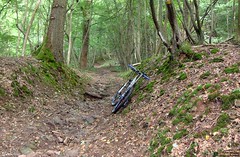
All that is left now is a 150 meter drop along some switchbacks down towards Huy. This is one difficult downhill. At first there are so many trails and tracks crisscrossing it is very difficult to choose the right one. They are steep and with hairpin turns. At times I just stop the bike and make the turn on foot. After a while some trees block the road. I climb over them and continue. I can see the town 50m below me when all of a sudden the track is blocked to the right. There is a small track leading left and it looks like my only option. At times I am very close to a big abyss to my right , I realize that there is no room for error here. Mind you, the trail is dry, I would not want to do this when the trail is wet. A steep drop brings me to the mouth of a railroad tunnel. I'm nearly there.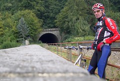
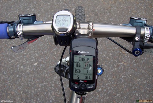
Ride Stats : 38,5K and 815/870 heightmeters (Polar/Garmin) in 3h00mins
Hill Factor : 22.5
O2 Bikers Roadbook Ben-Ahin at EveryTrail
Plan your trips with EveryTrail iPhone Travel Guides
6756/71510
Friday, September 3, 2010
O2 Bikers Roadbook Ben-Ahin
Sunday, August 22, 2010
Natuurvrienden TT Haasrode
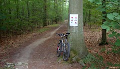
When I got out of bed this morning I still felt a bit tired from yesterdays' ride. I didn't have high hopes for my condition today but I had promised to be at the start in Haasrode at 7am so I rode out anyway. After a couple of hellos I rode off with another biker who would accompany me during the first kilometers until the 52 and 62K distance split. Meerdael forest was glistening with dew and the bikes were wet from riding through the grass on our way to the forest. It was warm with 19 degrees C but the forecast called for possible rain later in the day, even thunderstorms in the late afternoon. So the early biker got the worm today. After this intermezzo I rode on and when I arrived at Nethen I noticed an arrow had been removed at a crucial spot. A left turn . I replaced the arrow so that the bikers would not take the Bruyere de Wez going straight up - an 18% tarmac climb - but instead turned left for a steep offroad climb ending with a small step. A bit more of a challenge for a mountainbiker. I crossed someone from Mountainbike Tour Trips at the top of the climb. He was possibly also confused about the missing arrow. A bit further I descended back towards Nethen and stood at the start of the infamous Lianenklim. There is also an easier track, not through the deep and wet gully but following tarmac, cobbles and a track though the fields instead. I took the easy option. I wasn't sure about the condition of the track in the Lianenklim and I didn't want to be stabbed to death by gnats or even horseflies. I continued towards and through Bossut and after 20K into the ride I arrived at the first rest stop high up in Gottechain. There still were no bikers here, only members of the organisation. I told them of the missing arrow and advised they sent someone over to re-check. I then rode on, taking a very steep downhill that might make some victims among the 52 and 62K bikers that pass here. The 42K and other distances split off just after the rest stop so now I was on long-distances-only trails. Into and out of Grez and then crawling up the steep cobble climb to Biez. This is the start of a very intense section in Brabant Walloon, where a lot of heighmeters, some marvelous views and sheer fun are to be had for the mountainbiker. When I arrived at the first rest stop, I already had around 350 heightmeters, but the next section of 15K would easily double that amount. I was still riding alone and was enjoying the first rays of sunshine . The sections in the Forest de Glabais are some of the finest in the area. At times one could imagine being in the Ardennes. But I also know that this is amongst the last really tough climbs. I am nearing the 2nd rest stop at the edge of the Bois de Linsmeau and here I encounter the first real muddy puddles. But those who are 'in the know' can take a little singletrack that runs parallel to the muddy track. I take a break at the rest stop and have a little chat with the volunteers manning the stop. Thanks has to go to each and every one of them. They also sacrifice their free time to help us organise this ride.
When my bike companion for half an hour took a left at the 52/62K split I was riding alone through an awakening forest. My job was to control the signage , if needed replace broken or stolen signs and make sure the riders, who could officially start at 7.30am, would not get lost . When the trail is ridden in this direction - counterclockwise on the map - the toughest bit of the ride comes first. A loop with some solid climbs and tricky descents on the Nethen side of the Meerdael forest. The sand in the Savenel area was deep and stuck to my wet bike. The long climb up to the plateau again was immediately followed by a fast descent towards the Kluis. It made my glasses foggy with the contrasting warmth of my body against the crisp forest air. The loop through the Bois de Beaumont led me down the long hollow road towards Nethen. When I was near the end, I saw a rope that had been spanned over the road. There was a festival of some sorts in the fields surrounding the track and the two fields had been connected by ropes. I stopped and had a talk with one of the festival people. I explained him that there was a mountainbike event passing here and that it would be better to remove the ropes. So we did just that.
The sun was frequently obscured by clouds but it remained dry. The small grassy track leading down into Pietrebais demanded my full attention. Even though the grass had been mown a couple of days ago, there were still dangers hiding below the greenage. Hidden ruts and even stones can easily topple the unaware biker over. A long climb on tarmac takes me back out of Pietrebais and then downhill again through a forest on a dangerously washed-out track. I drop into Cocrou. Here care has to be taken, the small road to the right is easily overseen. But the signage is OK and only the fast and the furious will miss the turn. For them, we have put some extra signs further down into Cocrou village that will lead them back to the trail, eventually. The long climb through a beautiful hollow forest road from the Fond du Moulin up to the plateau through the Bois de Beausart stresses my legs.
The following downhill is a bit less dangerous than yesterday because the tree that had fallen over the trail has been removed. I also notice that the sandy bit is a little deeper than yesterday. I see my first bikers on the trails when I join the 42K riders coming from the left. From now on I can up my tempo a little bit and play catch-me-if-you-can with the other bikers. Some can catch and pass me , others try but die in my wheel. Life is fun.
The ride now mellows out a bit going though the fields between Gottechain and Tourinnes le Grosse. We cross the language border near Valduc and disappear into Meerdael Forest once again. A loop that takes us from the Walendreef and the Weertse Dreef to Mollendaal, the highest point of the forest, and then down into Bierbeek. A last climb following the De Betstraat hurts because it is long, grassy and difficult. Then I am back at the Haasrode Sports Complex where I started 65K , 3h48mins and over 900 heightmeters earlier. Riding back home I take a couple of backroads and small trails just for the fun of it. I had a good ride today.
Ride Stats : 73K and 930/1020 heightmeters (Polar/Garmin) in 3h56mins
Stats TT Haasrode : 65K and 935 heightmeters (Garmin)
Track on EveryTrail :
TT Haasrode Natuurvrienden 65K at EveryTrail
Plan your trips with EveryTrail iPhone Travel Guides
6393/68335
Sunday, July 4, 2010
18th Meerdael Classic - Oud-Heverlee
Been there, done that, got the T-shirt. Looks easy when you read this but this years' edition of the Meerdael Classic was not that easy. The weather had been very hot in the days leading up to the weekend , with a 33 degrees day on friday, and I didn't bike offroad since last monday. The fear of getting bitten by horseflies also kept me on the safe side of caution. Yesterday saw a little bit of rain during the day, but that was far from enough to change the dry conditions. This morning it was cool and fresh but it promised to be a good and sunny day. The track through Meerdael Forest takes me over the Naamsesteenweg and towards Haasrode where a first rest stop awaits us at the Bremberg We are 23K into the ride. Lots to eat and drink but they might have offered something more Sports-people minded than cookies and chocolate bars. There is water and also some sports beverage. After this welcome break the trail moves towards Bierbeek where we pass the start of one of the Meerdael Bloso trails. We also follow this trail, albeit in the opposite direction, and things are spicing up a bit now with the addition of a climb here and there in the Dikke Eik region. Passing the Naamsesteenweg again the trail now moves towards Nethen where more serious things await us. Starting with a nice singletrack followed by a technical descent into Nethen. A long climb over cobbles takes us up to the plateau but we descend right away back down and then venture into the Lianenklim. A local hotspot which consists of a long and technical uphill through a deep hollow road. Due to the dry conditions it is completely ride-able if you can deal with big sandstones, deep ruts and the occasional log. The trail then moves towards Bossut where a second rest stop is situated. 40K into the ride already. I borrow a pump to add some air to my rear tyre. Good thinking of the organisation to have a pump, chain lube and a small technical toolkit at every rest stop. The track now moves towards a beautiful long uphill along a very deep valley in the Bois de Laurensart. We are ride in file Indienne and it is impossible to pass the slower riders in front of me. I relax and take the moment to look around and gather my strenght. After a short stint on the plateau we drop down a very steep trail and arrive at the Gastuche side of Ottenburg. Slowly riding back up again between field and forest and we are set for a bit of fun next to Ottenburg. First a very small track leads me down to another track which takes me into a deep and lush valley. Covered with grass and surrounded by forest on 3 sides. A very beautiful spot. Here we meet the Red Overijse Bloso and they decided to take the next-to-impossible climb up the crest. They might have just followed the red and take the less steep climb instead. But no time to fret, we drop down again and I have to really dig deep to make the short steep uphill that follows. Crossing the road from Florival to Ottenburg for yet another climb. Crossing the road from Sint Agatha Rode to Ottenburg and down the tricky Oliestraat. I see a biker with a flat tyre. Careful here. Then follows the steepest climb of the day when we grind our way up the steep slope of Sint Agatha Rode Bos . I make it, lots of people don't. Crossing the road from Sint Agatha Rode to Ottenburg again, we did a loop , and a little further awaits the 3rd rest stop. I meet someone I know from years back when he was still with the Blancs Gilets. We ride some time together but he is too strong so I let him move away. The sun is out more now, and when I ride up the Zavelstraat that takes us close to Huldenberg I begin to feel my legs. Obviously they could not leave out one of the trickiest uphills on the Overijse trails. I make this one as well. Kudos go to the Moots . Here the Red Bull girls are waiting for us. Pity their beverage doesn't do full justice to their looks. Its what Red Bull calls cola but besides it being cold it doesn't taste like much. I add it to what is left in my drinking bottle and move along for the last 12K or so. The trail now takes us back to Nethen where we enter Meerdael Forest again and have to tackle another couple of climbs. The zooming downhills now demand full concentration. With the strength fading from the legs, I tend to let things hang out a bit on the downhills. Not a good idea when they are dusty and full of ruts. Dipping into Sint Joris Weert for a little bit and then moving towards Meerdaelhof where a sign tells us what we already knew. Only a couple of K to go now, before we reach the football field of the Zwarte Duivels, where I started some 6 hours ago for what proved to be one of the more difficult Meerdael Classics I have ridden. These are the facts as they appeared on my instruments after the ride. When I got home I discovered I had been very lucky today. I had felt a bump with every turn of my rear wheel but I couldn't pinpoint its source. I thought it must have been because of my wheel being out of true. But then I saw this
The Ride :
Got out of bed at 6am and took my time preparing for the start. Around 7.27 I set off, having pre-inscribed I also had a T-shirt coming my way but I decided to pick that up after the ride. The first bit of the ride took us into a cool Heverlee Bos for what may be considered an easy warmup. The trail moves towards Korbeek Dyle, not before following a lesser known track to get to the Natur Natur center. The sun is out but luckily there are also clouds which keep temperatures bearable. Moving towards the Heverleebos again the trail takes us into Vaalbeek and then after 18K we arrive into Meerdael Forest at last. 

Down into Archennes for a first loop which leads us to a sandy uphill. I did not manage it, I believe few did. It takes us up into the La Malaise area where a tricky downhill has many a brake a-squealing. Back up and towards Nethen again after another stony and rutty descent. Having local knowledge of the trails certainly helps because I see a lot of people struggling trying to find the good path to take you down. Back up again through a long hollow road climb that leads us towards Pecrot. Here a first highlight of the Classic follows. Taking the railroad singletrack, followed by a long climb up the crest and then zooming back down along a man-made downhill with lots of berms and whoops. Down in Florival the 100K leaves the 67K for an extra loop.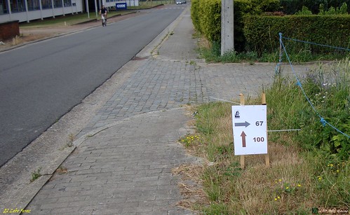
Down into Huldenberg again and then the trail follows the river Ijse for a while . A well - deserved break.
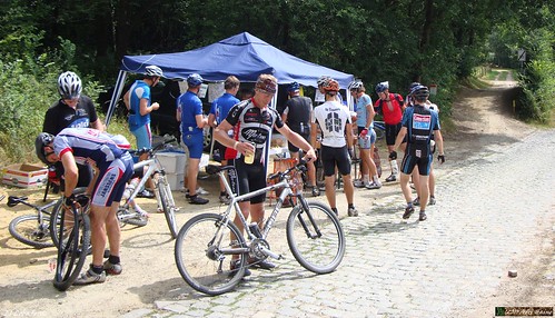
But not for long because now another highlight of this ride is upon us. They takes us into the Margijsbos and up the Smeyberg crest for no less than 5 climbs and downhills. Somewhere along those climbs we pass the 1000 heightmeters mark. Some nice singletrails here and they take advantage of every opportunity to make this 100K loop worthwhile. When we arrive in Sint Agatha Rode at last we get another easy bit before entering Marbaise and discovering the 4th rest stop.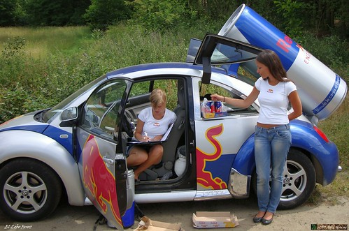

 . Scary to say the least. When you consider all the stones, lugs, cobbles, gravel and other nasties I have been riding over today its a small miracle that tyre didn't burst.
The Lowdown :
Not much can be added. Once again the Downhill Bikers have offered us a great ride. There were some new sections this year and - judging from the facts and the feeling in my legs - they made the ride more hilly. The organisers never fail to make the most of this region, without overdoing it. A subtle difference. Some new tracks - at leats for me - and several sections on the 100K distance that make this ride worth its while. This is the 18th version and of course this organisation is hard to fail. I might say they are nearly flawless.
If I am pressed to find a minus point I could say that they might consider adding some food that is more apt for Sports use. Cookies and chocolate bars only offer fast sugars, not the much needed slow ones.
What I liked :
+Great Trails, with attention to lesser visited tracks
+Arrowing was more than adequate and sufficient
+4 rest stops on the 100K
+Good signage before and after every split.
+Plenty of water and some sports bevarage, also Red Bull (+girls ! ) at the last rest-stop.
+Bananas and oranges are OK for Sports .
+Well organised bike-park with easy system to collect your bike afterwards
What I did not like:
-not enough variety in food offerings. Cookies and chocolate are not exactly energy food for Sports.
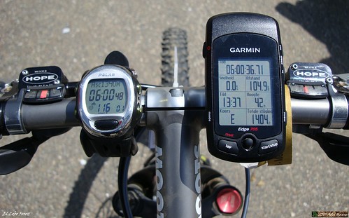
Ride Stats : 114K and 1380/1525 heightmeters (Polar/Garmin) in 6h14mins
TT Stats : 100K and 1490 heightmeters (Garmin)
Hill factor : 14,9
4952/52690
Saturday, April 17, 2010
Hallerbos Extra Vaganza
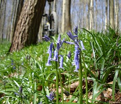
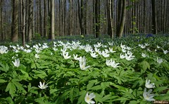
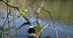
Every now and then I do something crazy. One of those things is riding long distances offroad on a mountainbike. Today was the perfect day for an extravagant ride. The plan was simple. Connect the Meerdael Forest to the Sonian Forest, move on towards the Hallerbos and there I would do a 35K/670hm ride I have on GPS. I've done this ride last year on the first of June. Today it was a bit earlier in the year but the weather looked promising and I was eager to find out whether the blue hyacynths would be in bloom. There was someone who would accompany me from the Sonian Forest onwards but at the last moment she cancelled her attendance. So it was a solo ride. And a long one. The loop first goes around the lakes at the 7 Fontaines and then follows the GR track along the edge of a field. A steep climb up towards the edge of the forest and then back down again to ride up to the forest again. This time I would spend a long time into Hallerbos. I noticed immediately that the bluebells weren't out in full force. I am not sure whether they already bloomed or if I just was a week too early. At any rate there don't seem to be as many of them as in previous years. The white flowers where already in full bloom. After a couple of trails in the forest I set towards crossing the highway and make my way towards Braine l'Alleud. There were a lot of small singletrails here, sometimes I had to look for them but whomever built the track was surely at home in this area. The track ondulates up and down, sometimes very steep but always fun and surprising. My legs began to feel the kilometers and I paused for a bit to eat. Before long I was at the Leembeek bos where the trailbuilder had incorporated a nice section into the lembeek area. Crossing the E25 again and I was back in Hallerbos. There were a lot of people around, some walking, some on horseback and others on bikes. Obviously they all were looking for the bluebells. Again they were there, but not as plenty as one would expect. Crossing the last ridge and I am back at the 7 Fontaines. Phew, 73K on the counter, only 35 left to go. Another bit to eat whilst I make some pictures of ducks and tortoises (!) basking in the sun on a tree that has fallen into the water. The ride back only varies a couple of times from the trails I took getting here. My neck starts to make me feel I'm not 25 anymore but I am more concerned with my GPS. I noticed the battery was nearly dead. Luckily I would make it home but it was a close call. I should have fully loaded it before I left, never trust it to be full. When I drop down the Smeysberg I have to wait for a local road race to pass. After the green flag car I can continue my way towards home. The ride was long and took a lot out of me. But the sun was out the whole day and even though I felt the northeasterly wind from time to time on my way back home, most of the ride I was in forests so it didn't bother me that much. As far as the bluebells are concerned. I could be wrong but I hope they still need a couple of warm days to reach full bloom. I spoke to a guide in the forest and he told me the next week would be prime time for the bluebells. Although he also had to concede the harsh winter took its toll. Like he said it : 'we can't command nature'. So true.
I started out over a new track I discovered only last week. First riding to Sint Joris Weert through the Meerdael Forest, then climb up the ridge of the Smeysberg but stay close to Neerijse. From there I could ride towards the Ganspoel and past the Duisburg water towers. I then disappeared into the Sonian Forest to connect in a straight line to Jezus-Eik. From there it's still about a 10K ride to St Genesius Rode and then to Dworp and the 7 Fontaines. After 35K and 1h46 or thereabouts I was at the start of my loop.

Ride Stats : 110K and 1350/1440 heightmeters (Polar/Garmin) in 6h2mins
2697/26465