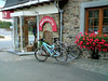
After a dry thursday it looked like we would have a nice and quiet ride in the sunshine today. When I got into my car at 6.50am the clouds were clear and there were wisps of mist hanging over the land. The river Meuse was breathing some heavy fog when I approached it and crossed the "Pere Pire" bridge in Huy. When I arrived at Stree there were already people getting ready to go. I met up with Geert aka Schijfrem. He also rides a Moots YBB and we decided to ride together as long as possible. I enscribed first and forked over 3.5€ for the 55K distance. There were also rides of 25, 35 and 45K. When I asked at the inscription if they had an emergency number, they replied they did not. Some joker suggested I call 100 in case of trouble. Yeah, that one minus point I honestly did not expect on a ride that carries the Stany Smol tag. Pity.
The Ride:
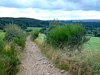
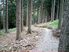
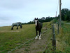
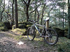
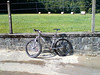
Geert and I set off for the first couple of K's which plunged us almost immediately into Outrelouxhe. I recognized the trail from my Nandrin rides and knew we were in for a treat. The trail plunged into a rift and then followed a little river into a narrow valley. The dropoff was very steep - I walked it, later I noticed it was a 37% gradient on the GPS track ! - and the singletrail following the river was ondulating up and down just enough to keep the tension on the muscles. Great section. A little later we emerged on tarmac for a short stretch taking us down to the first heavy climb of the day. Over loose rocks and shifting pebbles we worked our way up the slope that approached 19% at places and took us some 100 heightmeters up the plateau. From there we dropped down again - this downhill is well known to me from the Nandrin trails were it has to be conquered uphill - and again care needed to be taken. Heavy rains have seriously deteriorated this track and at times the slope was 21%. Try doing that on loose stones and you get the picture. Very concentrated and a great experience. Below we followed the river again until we were at the lowest point possible in this forest. The Fond d'Oxhe as it is called. Obviously another 100 heightmeter climb was bound to follow. Not as steep as the first one but the trail was very beautiful, with rocks, roots and gullies making it tough to ride. At the top the 45 and 55K distances were splitting off and Geert decided to follow the 45, leaving me alone to continue on the 55K. I made a picture of him before we parted .


The trail now entered some kind of walking trail nicely circling through rock gardens and forest outcrops. We met some walkers here - girls with dogs - and it was nice to notice they were all very friendly. Especially the dogs.
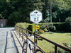
We stayed on the plateau a while and after an hours ride I came to the first ravito. This must have been some 17K into the ride. All distances merged here . There was some water and grenadine drink, cookies, waffles and also someone who was offering high-energy food and drinks of Nutrilite . I had a taste of everything and went on my way. I dropped down the slope again, before following a nice singletrail along the forest edge. On my right I could see the cooling towers of the Tihange nuclear plant. Impressive.


A long climb followed and gradually I was leaving the forest , coming out into the open fields before crossing the N66. A little later and after crossing the N641 there followed some very difficult climbs on rocks, roots and stones where I had to walk several times due to the slope and the wetness of the rocks. Just before Marchin I enjoyed the second rest stop of the day. This time there were some Red Bull girls to sheer us up and offer us some tasty beverage. I declined because I already have Red Bull mixed in my water bottle. But they were nice to look at.
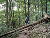
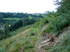
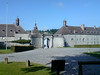
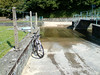
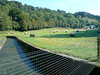
I passed the strangely curved church of Marchin and a tricky downhill - roots, stones, wet rocks - demanded my uttermost concentration to keep the rubber side down. A climb and descent into the field - with some grassy gullies to spice things a little and another steep descent before turning right onto what looked - and felt - like an abandoned railroad track. Nice section but I was glad I had a softtail bike here instead of a hardtail. The ondulating track brought me a few K's further before entering Modave. Here we had to follow some tarmac which led us to the entry gate of the castle grounds. Nice little downhill-uphill section here before I got to the 3rd rest stop of the day, exactly 40k into the ride. A great passage on the castle grounds followed , with a very tricky downhill and a passage through a ford. I didn't notice there was a bridge until I got my feet wet from the splashing water. But the sun was out and with some 20 degrees and no wind I didn't mind getting my feet wet. After Modave the slopes were getting a bit milder and before long I was out in the fields again. I noticed my rear tyre was slowly losing air so I decided to replace the inner tyre. Some stony fieldtracks and field passages giving way to amazingly narrow but very beautiful tracks brought me into Ramelot. Another ravito some 50K into the ride and the last couple of K's consisted of twisting trails into moist forests and a passage over a freshly harvested field. Crossing the N66 not far from Tinlot I knew what was coming. An uphill passage through a hollow road edged with trees but followed by a very wet downhill leading back towards Stree. I took the edge of the field on the left of the track instead of all the puddles and was rewarded by an almost clean bike when we finally made it back to the start.
There Geert was already tasting some fine beer and we shortly exchanged our experiences .
The Lowdown:
What I liked:
+ Great trails, with attention to lesser visited tracks
+ the region and the use they made of what is offered
+ dangerous downhills and road crossings well marked on shared trails for all distances
+ distance splits well marked - before AND after the split
+ arrowing sparse but suffiecient and very noticeable
+ 4 rest zones - fruit, cookies , grenadine and water.
+ Red Bull and Energy Drinks stands.
+ all this for only 3.5€
What I did not like:
- no emergency numbers provided by the organisation
- less heightmeters than announced
- no danger signs on the 55K-only sections
Synopsis:
Obviously the trails were beautiful, in the beginning very tough in the forest section south of Tihange, with some very steep downhills and a couple of 100 heightmeters + climbs, difficult and long. In the end the ride didn't deliver the amount of heightmeters the organisation had promised, but I didn't really mind. We got nearly 1100 heightmeters on the 55K - that turned out to be almost 60K. And the tracks were never boring, instead surprising me all the time with nice finds and great views. A good knowledge of the local tracks leads the organisors to produce one hell of a ride. The arrowing was sparse at times - I missed an arrow twice - but the arrows used were very visible - black on yellow - and you could spot them from far. The distance splits were very well marked - both before and after the split. A minus point would be the fact that on the loops the 55K did seperately from the other loops, there were no danger signs before tricky downhills. They had danger signs on the shared loops with the other distances. Do they think that the 55k riders were all so experienced they didn't need to be warned? I would include the signs the next time.
The 4 rest stops were well stocked, water and grenadine and some cookies, fruit and waffles. Nothing fancy but with some Energy drinks and food at the first, and the Red Bull girls at the second rest stop who can complain? And all this for a mere 3.5€ ? Yes, indeed. I have no idea about the showers and the bike cleaning facilities since I didn't use either of them. I returned home happy and with a few more tracks to possibly include into my Nandrin trails.
The only point that I would suggest the organisers fix urgently , is the lack of emergency numbers. Some of the downhills were really tricky and I saw a lot of people with broken chains and other mechanical problems. Provide an emergency number please.
The Ride:
Geert and I set off for the first couple of K's which plunged us almost immediately into Outrelouxhe. I recognized the trail from my Nandrin rides and knew we were in for a treat. The trail plunged into a rift and then followed a little river into a narrow valley. The dropoff was very steep - I walked it, later I noticed it was a 37% gradient on the GPS track ! - and the singletrail following the river was ondulating up and down just enough to keep the tension on the muscles. Great section. A little later we emerged on tarmac for a short stretch taking us down to the first heavy climb of the day. Over loose rocks and shifting pebbles we worked our way up the slope that approached 19% at places and took us some 100 heightmeters up the plateau. From there we dropped down again - this downhill is well known to me from the Nandrin trails were it has to be conquered uphill - and again care needed to be taken. Heavy rains have seriously deteriorated this track and at times the slope was 21%. Try doing that on loose stones and you get the picture. Very concentrated and a great experience. Below we followed the river again until we were at the lowest point possible in this forest. The Fond d'Oxhe as it is called. Obviously another 100 heightmeter climb was bound to follow. Not as steep as the first one but the trail was very beautiful, with rocks, roots and gullies making it tough to ride. At the top the 45 and 55K distances were splitting off and Geert decided to follow the 45, leaving me alone to continue on the 55K. I made a picture of him before we parted .
We stayed on the plateau a while and after an hours ride I came to the first ravito. This must have been some 17K into the ride. All distances merged here . There was some water and grenadine drink, cookies, waffles and also someone who was offering high-energy food and drinks of Nutrilite . I had a taste of everything and went on my way. I dropped down the slope again, before following a nice singletrail along the forest edge. On my right I could see the cooling towers of the Tihange nuclear plant. Impressive.
I passed the strangely curved church of Marchin and a tricky downhill - roots, stones, wet rocks - demanded my uttermost concentration to keep the rubber side down. A climb and descent into the field - with some grassy gullies to spice things a little and another steep descent before turning right onto what looked - and felt - like an abandoned railroad track. Nice section but I was glad I had a softtail bike here instead of a hardtail. The ondulating track brought me a few K's further before entering Modave. Here we had to follow some tarmac which led us to the entry gate of the castle grounds. Nice little downhill-uphill section here before I got to the 3rd rest stop of the day, exactly 40k into the ride. A great passage on the castle grounds followed , with a very tricky downhill and a passage through a ford. I didn't notice there was a bridge until I got my feet wet from the splashing water. But the sun was out and with some 20 degrees and no wind I didn't mind getting my feet wet. After Modave the slopes were getting a bit milder and before long I was out in the fields again. I noticed my rear tyre was slowly losing air so I decided to replace the inner tyre. Some stony fieldtracks and field passages giving way to amazingly narrow but very beautiful tracks brought me into Ramelot. Another ravito some 50K into the ride and the last couple of K's consisted of twisting trails into moist forests and a passage over a freshly harvested field. Crossing the N66 not far from Tinlot I knew what was coming. An uphill passage through a hollow road edged with trees but followed by a very wet downhill leading back towards Stree. I took the edge of the field on the left of the track instead of all the puddles and was rewarded by an almost clean bike when we finally made it back to the start.
There Geert was already tasting some fine beer and we shortly exchanged our experiences .
The Lowdown:
What I liked:
+ Great trails, with attention to lesser visited tracks
+ the region and the use they made of what is offered
+ dangerous downhills and road crossings well marked on shared trails for all distances
+ distance splits well marked - before AND after the split
+ arrowing sparse but suffiecient and very noticeable
+ 4 rest zones - fruit, cookies , grenadine and water.
+ Red Bull and Energy Drinks stands.
+ all this for only 3.5€
What I did not like:
- no emergency numbers provided by the organisation
- less heightmeters than announced
- no danger signs on the 55K-only sections
Synopsis:
Obviously the trails were beautiful, in the beginning very tough in the forest section south of Tihange, with some very steep downhills and a couple of 100 heightmeters + climbs, difficult and long. In the end the ride didn't deliver the amount of heightmeters the organisation had promised, but I didn't really mind. We got nearly 1100 heightmeters on the 55K - that turned out to be almost 60K. And the tracks were never boring, instead surprising me all the time with nice finds and great views. A good knowledge of the local tracks leads the organisors to produce one hell of a ride. The arrowing was sparse at times - I missed an arrow twice - but the arrows used were very visible - black on yellow - and you could spot them from far. The distance splits were very well marked - both before and after the split. A minus point would be the fact that on the loops the 55K did seperately from the other loops, there were no danger signs before tricky downhills. They had danger signs on the shared loops with the other distances. Do they think that the 55k riders were all so experienced they didn't need to be warned? I would include the signs the next time.
The 4 rest stops were well stocked, water and grenadine and some cookies, fruit and waffles. Nothing fancy but with some Energy drinks and food at the first, and the Red Bull girls at the second rest stop who can complain? And all this for a mere 3.5€ ? Yes, indeed. I have no idea about the showers and the bike cleaning facilities since I didn't use either of them. I returned home happy and with a few more tracks to possibly include into my Nandrin trails.
The only point that I would suggest the organisers fix urgently , is the lack of emergency numbers. Some of the downhills were really tricky and I saw a lot of people with broken chains and other mechanical problems. Provide an emergency number please.
The Bare Facts:
Profile of the Ride : CLICK
Profile the organisors provided:

Map of the Ride :

Pictures of the ride by Schijfrem : CLICK
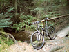
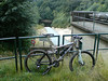
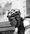
[the Moots dude with the long pants is ME]
Ride Stats :
60K and 1090/1145 heightmeters (Polar/Garmin) in 3h46mins
Hill Factor:
18.17
6740/67195