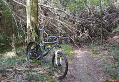
Time to get Mr.Merlin out and do some serious biking in the Ardennes. Or, in this case, the gates to the Ardennes, Ben-Ahin which is a suburb of Huy, near the river Meuse. The O2 Bikers roadbook of Ben-Ahin is already an old one, dating from their number 70 issue from June 2001. It is however, a roadbook that received a lot of credit as being tough, both uphill and especially downhill, with the drop from the Tour Joseph back to the town of Huy as being the epitome of downhill tracks in the region. So today, at last, I rode my MPS towards Huy and parked at the parking lot opposite the Hotel du Fort. This loop starts with a very beautiful but very steep and dangerous downhill. Think in the region of 25% grade, even more. Near the end I am literally sitting on my rear tyre to keep the weight back while I control the speed of the bike. Luckily there are some ground patches between the rocks where I can apply the brakes without risking a washout. I arrive on a tarmac road I follow briefly before entering the forest again. Another climb takes me to a next patch of tarmac and another trails brings me ultimately into Boussale. From there I move towards Andenne, where - at the Col de la Flismes - the track at last veers to the right and brings me back to the river Meuse. Some very nice trails here in the forests. There is a sign with 'Pietons Seulement' - pedestrians only - and I'm betting that most will be indeed going on foor here. The climb is steep, and the trails is riddled with rocks making it very difficult to find traction and keeping the wheels spinning. At the top I follow a narrow track taking me through a field with two basculating gates. The trail then turns back into the forest for another drop down the slope. At the end I nearly have to make a 180 turn that brings me on a small singletrail following a river. The trail ascents and after a while it again becomes too steep to ride. So I walk another 100 meters before the slope lessens. The peak grade on this slope shows 38%. No mere mortal can ride that I'm sure. I arrive in Saint Leonard and have to climb some more on tarmac roads before reaching the Tour Joseph. Crossing the tunnel and I arrive at a bridge from where I see my car down below on the parking lot. Some steps take me down to the road and I am very happy to have survived this difficult ascent at the end of a very physical ride. When I look at the numbers on my Polar and Garmin screen I realize that the 900 heightmeters announced were a bit optimistic. certainly so if you take into account I did one 4K loop 2 times,adding perhaps 70 heightmeters to the normal number. Afterwards on the PC the Garmin software gives me 870 heightmeters. And I can live with that. Especially since most of them were very hard-fought, steep height differences. I realized today that I need some more Ardennes rides to get into better form. I have the endurance but it has been a while since I had to tackle long steeps climbs and descents. 
The mist that hung over the country was slowly getting dissipated by the sun so things looked good weather-wise. The roadbook promised nearly 900 heightmeters over close to 34K. More was not needed to draw me out and give it a try.
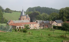
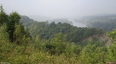
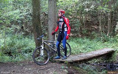
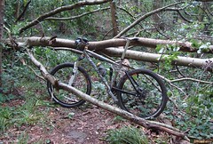
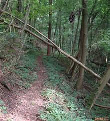
From the start a section of tarmac brings me along the borders of the river Meuse towards the roundabout where a tarmac climb starts. I pass the Chateau of Ben-Ahin - I think thats what the sign said - and then I am riding offroad and getting used to my first couple of kilometers on the Merlin again. The route climbs gently out of the valley and on top of a long climb I am presented with a magnificent view of the river deep below, with some shrouds of mist still hanging over the faraway hills. The trail drops down again and some sharp rocks remind me that I am in the Ardennes and care has to be taken. Below I follow a river upstream until where a multitude of tracks come together on my Garmin screen. I know this is the spot where the trail comes 2 times but I am not sure which direction I should take first. I fumble with the screen and see there is a loop lying ahead of me. I decide to go for that and it takes me onto small singletracks vlimbing more or less all the time. Sometimes a fallen tree blocks the track and getting over it isn't always easy. At one point I make a wrong turn but I can see on my GPS that I will connect to the track again a little bit further. I arrive at Solieres and after some tarmac I drop down on a rooty singletrack into the forest again. Getting my feet wet riding through a little river and then a long steep climb though a hollow road. Steep but just manageable. After a while a tricky downhill brings me into Ben-Ahin where I am taken on a second loop.
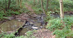
I follow the river Meuse for a while and if I might give a tip to anyone wanting to ride this track, take advantage of this flat section to recuperate because the climb that will follow is a very nasty one. You follow the Meuse valley until you reach Ben, and there starts a climb that will have you dig deep into your strenght and technical prowess. In fact , you are following what looks to be a little dried-out river and it takes you up along the outskirts of a rocky outcrop. Later when I download the track to my PC I moticed peaks of 24% in this climb. It takes a while before it gets less steep and then brings me back into Ben-Ahin, where I have started this second loop a while ago. Seems like I did the first loop in the reverse direction so I decided to do it again, in the right direction this time. So back to Solieres and back down along the track with the many fallen trees. Back at the junction I am taken to another very steep climb.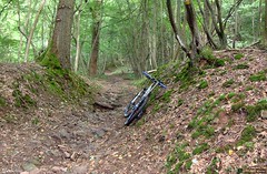
All that is left now is a 150 meter drop along some switchbacks down towards Huy. This is one difficult downhill. At first there are so many trails and tracks crisscrossing it is very difficult to choose the right one. They are steep and with hairpin turns. At times I just stop the bike and make the turn on foot. After a while some trees block the road. I climb over them and continue. I can see the town 50m below me when all of a sudden the track is blocked to the right. There is a small track leading left and it looks like my only option. At times I am very close to a big abyss to my right , I realize that there is no room for error here. Mind you, the trail is dry, I would not want to do this when the trail is wet. A steep drop brings me to the mouth of a railroad tunnel. I'm nearly there.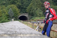
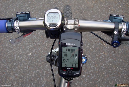
Ride Stats : 38,5K and 815/870 heightmeters (Polar/Garmin) in 3h00mins
Hill Factor : 22.5
O2 Bikers Roadbook Ben-Ahin at EveryTrail
Plan your trips with EveryTrail iPhone Travel Guides
6756/71510
Friday, September 3, 2010
O2 Bikers Roadbook Ben-Ahin
Subscribe to:
Posts (Atom)