I had received an invitation for this mtb orienteering event from one of the organisers of the SLOK 2009 Kesselberg MTB-O. Since I'm always in for something including my mountainbike and furthermore I also love the region I decided to take part in this race. The SLOK had set out 3 parcours - 10, 15 and 20K - in the hilly region around Kessel Lo and Linden. The start was given at the Abbey of Vlierbeek. Nicely situated in a broad valley just southwest of the Kesselberg area. I rode over from home to arrive around 11am at the 'Rozenkrans' pub where the inscriptions were taken. Since it was my first ever orienteering event I wasn't sure what to expect. But at the inscription I was ably explained the basic rules . You get a map with on it several marked and numbered points. You have to get from one point to the other - choosing your own way - and get a mark at each of the points. For that you receive an EMIT chip. This chip records a timemark when you put it in the trasmitter situated on the marking point. At the end of the race, this information is downloaded from your EMIT chip into a computer and you get your result. The one that completes the complete tour in the shortest time, is the winner. Simple, but as with all things, it isn't as easy as it sounds.
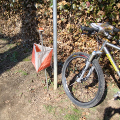
After the inscription I followed the markings towards the official start. Here I received my map and the girl explained to me how I should go about putting my EMIT in the marking stations. She already made the first mark so my race was already running when I was still there listening to her explaining me how things worked. I had brought the cardholder I used in the 2000 Coast to Coast Pyrenees so I could put my map there. The EMIT module I could fasten to one of my fingers.
At the inscription they asked for my identity card as a guarantee against the EMIT but I wasn't going to leave that behind. So they had to settle for my UCI licence.
Looking at the map I got underway and I quickly learned that riding fast AND trying to read a map at the same time wasn't easy. Furthermore I had to refold and turn my map all the time - my card holder is only A4 and the map we got was nearly A3 format. The 'real' orienteering guys had some kind of rototable on their handlebar. So they could turn the map to keep the place where they were going to, on top and in the front.
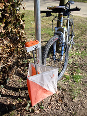
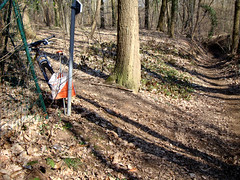
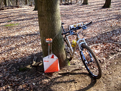
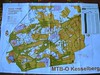
The weather was great, after a cold start the sun shone in truely spring fashion and riding through and around forests was a joy today. In the meantime I had arrived at my first marker and took a few pictures before heading off to the next one. The first couple of markers were relatively easy, but then things got more complicated, with a mixture of big and smaller tracks. You had to find the quickest path, and this was not always the shortest one. The difficulty was that in order to make a good time, you needed to look at the map and make a decision on the trail which you wanted to follow, whilst driving your bike through offroad trails. Sometimes they were easy, but there were also some steep downhills and sections with gullies . Luckily all the tracks were bone-dry. Here lies one of the big challenges of this sport. You obviously need map-reading skills, but you also need fitness and sometimes catlike reactions when your wheel hits a branch at the exact time when you were peering down at your map deciding on your next direction change. When things really got complicated - read, when there were a lot of tracks converging or several forks really close one after the other, I did stop and had a GOOD look at the map. One mistake could set you off in a completely wrong direction. Fortunately I am pretty good at reading a map and I didn't make a single mistake trackwise. Approaching Marker #12 ( see the map below ) I chose a dotted line which looked to lead to marker 12 very nicely, but all of a sudden I couldn't see any more trails, so I clambered up a very steep hill. This must have been my lucky day since I arrived on top at the exact location of the marker. While I was there I saw some other riders arriving from a different direction. Obviously I had taken the more difficult - but shorter - path. The section with markers 14 to 17 was also a very nice one, by now I was getting more confident and during the last section I really got under steam. In the end, connecting all the markers took me almost 37K and 2h02 of riding time.
I am very happy to have done this, its a combination of several skills and it involves riding a bike in nature. The only pity is that there are not that many MTB-O events around in Belgium. Next year this event will be held in my own Meerdael forest and I will look forward to participate to that. In the meantime I will certainly look out for similar events in Belgium, I had a really good time. Thanks to all the people at SLOK for making this event possible and to Jef Boeckx for bringing it to my attention.
Ride Stats : 61.5K and 570/588 (Polar/Garmin) in 3h11minsAfter the inscription I followed the markings towards the official start. Here I received my map and the girl explained to me how I should go about putting my EMIT in the marking stations. She already made the first mark so my race was already running when I was still there listening to her explaining me how things worked. I had brought the cardholder I used in the 2000 Coast to Coast Pyrenees so I could put my map there. The EMIT module I could fasten to one of my fingers.
At the inscription they asked for my identity card as a guarantee against the EMIT but I wasn't going to leave that behind. So they had to settle for my UCI licence.
Looking at the map I got underway and I quickly learned that riding fast AND trying to read a map at the same time wasn't easy. Furthermore I had to refold and turn my map all the time - my card holder is only A4 and the map we got was nearly A3 format. The 'real' orienteering guys had some kind of rototable on their handlebar. So they could turn the map to keep the place where they were going to, on top and in the front.
I am very happy to have done this, its a combination of several skills and it involves riding a bike in nature. The only pity is that there are not that many MTB-O events around in Belgium. Next year this event will be held in my own Meerdael forest and I will look forward to participate to that. In the meantime I will certainly look out for similar events in Belgium, I had a really good time. Thanks to all the people at SLOK for making this event possible and to Jef Boeckx for bringing it to my attention.
MTB-O Stats : 37K and 408 heightmeters in 2h02mins
MTB-O Official result : 2h19mins52secs on 23280m or 6mins/km
MTB-O Map
Garmin Map:

Organisers blog : CLICK
Official results : CLICK
1929/16075

No comments:
Post a Comment