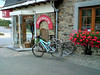
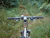
Today I had made another appointment with Albert Dumont to ride part II of the Verviers 2007 MTB Marathon World Championships trail. We met up at the Ardennes Outlet centre in Verviers. The weather had been dry and hot these last few days but now some menacing clouds and a stiff breeze made it less warm and in fact better suited for biking. Because the Moots was still at Filip Sport I took the Merlin out today.
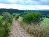
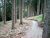
From downtown Verviers we first had to make our way up to Heusy and next to Mangombroux to go offroad along the Domaine Militaire in the Bois de Jalhay. Albert was talking about the history of Verviers in its golden age but before long we had to concentrate on the track that was very stony and running uphill all the time - "french flat" Albert calls it . When the track evened out a little bit we were making our way over roots and next to big puddles. After crossing the N679 we had a good view of the dark forests lying in front of us. A fast stony downhill followed by a climb brought us to Surister. The Merlin was already proving its worth. The rear suspension providing more traction in the climbs and also having a 22 chainring in front was a blessing on the very steep hills (I saw many 20%+ gradients on my GPS profile) . And obviously, having 10cm of travel in front and rear was a big bonus in the downhills.
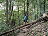
From Surister we had to make our way towards the River Hoegne. The descents were very technical at times and it was a joy to be able to ride them all - when they were not blocked by fallen trees that is. When we crossed the river Hoegne for the first time , we were in for a real treat. A singletrack meandering up and down high above the river brought us to the next crossing. When I ride my "Longest Downhill" I stay close to the Hoegne, but next time I will certainly try to use this singletrack which starts close to the Croupet du Moulin.
At the Croupet du Moulin we disappeared upwards into the Foret Domaniale de Gospinal for a series of tough climbs followed by tricky downhills. The forests were very beautiful but the loops were taking a lot of strenght out of my legs. Still, the pace was right and the bike was giving me more comfort than the Moots could do. When we came back down to the Hoegne at last we had around 22K and just short of 600 heightmeters.
Wow, this was one intense start. From the Hoegne we then made our way to the northeast and into Charneux. Time for a first snack before we arrived in Jalhay a few kilometres later. Not after another downhill followed by another climb of course. The track builder, Léon Hoenders, was in my mind a lot of time. This man not only seems to know all the nicest trails around here, but he also had a bit of a sadistic streak to him. But, obviously, this was not your "average organised ride" trail - with all due respect to those. No, we were on a World Championship trail and this was supposed to be a very tough and taxing ride.

At Jalhay we took a break to stock some food and drink. When we rode out of Jalhay and back to the trail, we had to take shelter because of a light rain shower. Mmm, some of those clouds were dense enough to contain showers. Still, the temperature was around 20 degrees and the shower seemed to be very local. We were lucky.
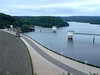
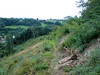
From Jalhay the trail made its way towards the majestic Westhertogenwald. Instead of the pine trees we would now enter a forest where broad-leaved trees are more common. The Hertogenwald extends over 12000 hectares and contains the Barrage de la Gileppe which we would soon encounter, but not after spending many many a drop of sweat. We were enjoying the majestic splendour of this forest and when we caught our first glimpse of the gigantic lake through the trees it would still elude us for many kilometres to come.
First we had to climb up to the highest point of our route - 456metres - next to the N68 before returning fullspeed into the Trou Malbrouck. Here Albert took me to the fawcett of the Tunnel de la Soor, a 2.5 k long tunnel dug to feed extra water into the Gileppe lake. He also told me about the disaster during its building, taking the lifes of 8 men when they drowned in that pipe during heavy rains. Now the outlet was only producing a trickle of water but after heavy rains the force of the water provides for a 50-metre long geyser. Impressive.
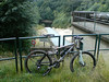
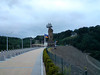
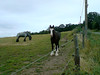
From the Trou Malbrouck the trail would now have us flirting with the Gileppe lake a couple of times, but we would have to climb away from it - and some very steep climbs at that - several times before we finally made it to the barrage. In the forest we also did a very nice singletrack downhill. We paused at the barrage to take some pictures of the famous Lion, looking very stern towards the Northeast.
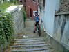
From the barrage we now made out way up towards to a viewpoint - took a picture there - and then disappeared into the forest once more for another series of climbs and descents taking us through the Bois de Goë and the Bois de Hevremont towards Hevremont. The toughest bits were now behind us but Léon still provided for a few surprises. Some very nice tracks near Brou and some beautiful singletrack that would eventually drop us near the river Vesdre east of Ottomont. Some tracks through Verviers itself, with stairs running up and down to wring the last bits of strenght our of our legs and demand high concentration before we spotted the Ardennes Outlet parking lot and the end of our journey.


Another tough ride. The Hill factor was not as high as the first part, and the ride was less intense but still this is a tough ride. Especially the parts next to the river Hoegne and the Hertogenwald are very demanding - both the uphills and the technicity of some of the downhills - but the beauty of the surroundings make you forget a lot of the suffering. It is impossible to capture all the trails and tracks into writing, you just will have to ride this track to really understand the beauty and the difficulty of it. But be prepared, this is a ride that will take you anywhere between 4 and 6 hours or more to complete - riding time that is !
Thanks to Albert for guiding me around this majestic trails . The Merlin proved to be a great bike - again and we were lucky with the weather - again. Thanks also to Léon Hoenders, the architect of one of the toughest - and certainly most beautiful - trails in Belgium.
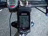
My first ride with the Garmin Edge 705 also proved to be a success. I was a bit worried it would jam the workings of my Polar S710 (which the older Garmin Geko did) but I had no trouble with that. Having all the information on one screen was great, and of course looking at the track afterwards provided a lot of information. Another one won over for GPS.
Ride Stats : 70km and 1665 / 1758 heightmeters (Polar / Garmin) in 5h00mins
Ride profile : CLICK
Hill Factor : 23.8
From downtown Verviers we first had to make our way up to Heusy and next to Mangombroux to go offroad along the Domaine Militaire in the Bois de Jalhay. Albert was talking about the history of Verviers in its golden age but before long we had to concentrate on the track that was very stony and running uphill all the time - "french flat" Albert calls it . When the track evened out a little bit we were making our way over roots and next to big puddles. After crossing the N679 we had a good view of the dark forests lying in front of us. A fast stony downhill followed by a climb brought us to Surister. The Merlin was already proving its worth. The rear suspension providing more traction in the climbs and also having a 22 chainring in front was a blessing on the very steep hills (I saw many 20%+ gradients on my GPS profile) . And obviously, having 10cm of travel in front and rear was a big bonus in the downhills.
From Surister we had to make our way towards the River Hoegne. The descents were very technical at times and it was a joy to be able to ride them all - when they were not blocked by fallen trees that is. When we crossed the river Hoegne for the first time , we were in for a real treat. A singletrack meandering up and down high above the river brought us to the next crossing. When I ride my "Longest Downhill" I stay close to the Hoegne, but next time I will certainly try to use this singletrack which starts close to the Croupet du Moulin.
At the Croupet du Moulin we disappeared upwards into the Foret Domaniale de Gospinal for a series of tough climbs followed by tricky downhills. The forests were very beautiful but the loops were taking a lot of strenght out of my legs. Still, the pace was right and the bike was giving me more comfort than the Moots could do. When we came back down to the Hoegne at last we had around 22K and just short of 600 heightmeters.
Wow, this was one intense start. From the Hoegne we then made our way to the northeast and into Charneux. Time for a first snack before we arrived in Jalhay a few kilometres later. Not after another downhill followed by another climb of course. The track builder, Léon Hoenders, was in my mind a lot of time. This man not only seems to know all the nicest trails around here, but he also had a bit of a sadistic streak to him. But, obviously, this was not your "average organised ride" trail - with all due respect to those. No, we were on a World Championship trail and this was supposed to be a very tough and taxing ride.
From Jalhay the trail made its way towards the majestic Westhertogenwald. Instead of the pine trees we would now enter a forest where broad-leaved trees are more common. The Hertogenwald extends over 12000 hectares and contains the Barrage de la Gileppe which we would soon encounter, but not after spending many many a drop of sweat. We were enjoying the majestic splendour of this forest and when we caught our first glimpse of the gigantic lake through the trees it would still elude us for many kilometres to come.
First we had to climb up to the highest point of our route - 456metres - next to the N68 before returning fullspeed into the Trou Malbrouck. Here Albert took me to the fawcett of the Tunnel de la Soor, a 2.5 k long tunnel dug to feed extra water into the Gileppe lake. He also told me about the disaster during its building, taking the lifes of 8 men when they drowned in that pipe during heavy rains. Now the outlet was only producing a trickle of water but after heavy rains the force of the water provides for a 50-metre long geyser. Impressive.
From the Trou Malbrouck the trail would now have us flirting with the Gileppe lake a couple of times, but we would have to climb away from it - and some very steep climbs at that - several times before we finally made it to the barrage. In the forest we also did a very nice singletrack downhill. We paused at the barrage to take some pictures of the famous Lion, looking very stern towards the Northeast.
From the barrage we now made out way up towards to a viewpoint - took a picture there - and then disappeared into the forest once more for another series of climbs and descents taking us through the Bois de Goë and the Bois de Hevremont towards Hevremont. The toughest bits were now behind us but Léon still provided for a few surprises. Some very nice tracks near Brou and some beautiful singletrack that would eventually drop us near the river Vesdre east of Ottomont. Some tracks through Verviers itself, with stairs running up and down to wring the last bits of strenght our of our legs and demand high concentration before we spotted the Ardennes Outlet parking lot and the end of our journey.
Thanks to Albert for guiding me around this majestic trails . The Merlin proved to be a great bike - again and we were lucky with the weather - again. Thanks also to Léon Hoenders, the architect of one of the toughest - and certainly most beautiful - trails in Belgium.
My first ride with the Garmin Edge 705 also proved to be a success. I was a bit worried it would jam the workings of my Polar S710 (which the older Garmin Geko did) but I had no trouble with that. Having all the information on one screen was great, and of course looking at the track afterwards provided a lot of information. Another one won over for GPS.
Ride Stats : 70km and 1665 / 1758 heightmeters (Polar / Garmin) in 5h00mins
Ride profile : CLICK
Hill Factor : 23.8
6366/63055

No comments:
Post a Comment